

 The ferry journey from Portsmouth to Caen is the closest I could find to the route taken by British soldiers in their liberation of Normandie on June 6th 1944 – D Day.
It arrives not in fact in Caen but in the port of Ouisterham, adjacent to the long thin stretch of sand now known as Sword beach. The armies of other nations landed further along the 120km of Normandy coastline designated the liberation front by allied high command.
Even though Caen is only a handful of miles further inland it was not liberated until July 20th 1944. There is a beautiful flat cycle path straight from the ferry terminal. Cycling along it and alongside Sword beach i found it hard to imagine what level of misery and tragedy those 50 days must have brought. It must have been hell.
The people of Normandie paid a high price for their liberation – 18,000 civilians were killed during the campaign. Their resistance groups committed over 1000 acts of sabotage to help the liberation. Families risked their own lives to shelter allied troops.
It is clear that there is an abiding love of the liberation story in Normandie. People are proud to fly multiple flags in their gardens. I passed a giant replica of the Statue of Liberty in one window. This is not the celebration of military victory but of freedom itself.
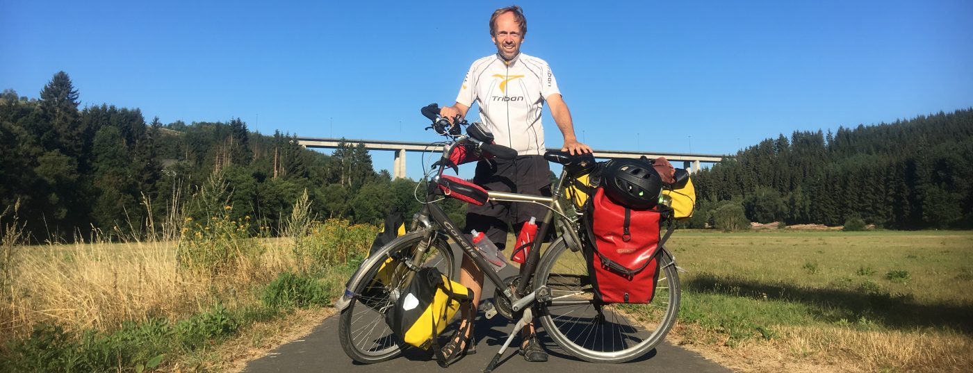
I learnt early on in my ride that the people of Normandie also
adore a cyclist who is over carrying – my euphemism for bad packing. Within 2 minutes of leaving passport control I received a round of applause from a group of middle aged promenaders. Did they shout bravo? I like to think so.
And so it continued for the next 50kms. Jolly bonjours, horn toots, even a fist salute on one tricky ascent. At last I know what it feels like to be appreciated by other road users!
I had booked into a campsite near Omaha beach, almost half way along the landings coastline. En route it was hard not to stop at the many monuments, signs and memorials depicting the liberation story. But with 3.5 hours till nightfall and legs delivering 12kms an hour I was wary of giving everything the time it deserved. The maths did not add up.
At a particular moment I noticed I was riding into a reddening sun, and every glorious falling shade of it made me think of a thing I shouldn’t have packed. The disadvantage of Google maps is knowing how far you have to go, and how far you’ve been. At some point I chose not to look. I just watched me the dot moving along a line on the map and knew this was a good thing.
Bereft of calories I found myself struggling up a hill at one point, only to find in front of me a giant monument staring out to the sea, chaperoned by flags and lit from behind by the countdown sun.
The sight of it took me up the hill where the calories could not. By the brow there was a car park. I pulled into it and devoured a Waitrose sandwich I had bought in Portsmouth the day before. Never have I loved asparagus more. Or Waitrose. Or my own foresight.
I must have looked like a hungry dog to the quiet dignified rememberers around me.
Darkness fell mercifully slowly. When it came I passed a family eating dinner around a table in their front garden. I wanted to force myself upon them and wondered how long they had been there and how many courses had passed.
The greetings continued but were now bon soir. I adjusted. A moped cyclist fantastically stalled as he passed me and I was able to get directions. “Two kms more”.
Next came a beautiful sight. A restaurant named Liberty. I found it hard to pass. But within 5 minutes I had parked my Gazelle and was looking for the owner of Camping d’hypo camp, which according to Google translates as hypo camp. Who knew?

Bravo sounds amazing x
LikeLike
Was amazing and very moving.
LikeLike
Lovely day for it – been miserable here thanks to ‘Brian’. Loving the reports – keep it up. Cx
LikeLike
Some people are never satisfied! Hope it passes soon. More news soon! Ax
LikeLike
Sounds like a good first day and a hard ride. Lots to see and write about, eat some food. Like the photos.
LikeLike
Thanks Mum. Yes, working out my routine now! I’ll try and write up some more tonight but also heading out to Mont Saint michel for evening stroll.
LikeLike